Rize - Kaçkar Mountain Range
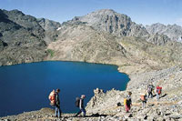 Looking like a pristine natural park, the Kackar Mountains between Rize and Hopa have a dazzling array of plants and animals, clear blue lakes, green forests and razor-sharp glaciers which can be seen year-round. The highest peaks in the range are Altiparmak (3480m), Kavran (3932m) and Vercenik (3710m).
Every year hundreds of climbers visit Kackar Mountain, whose southern face offers an easy climb. If there was no fog, there is a magnificent view of the mountains of the eastern Black Sea. The northern face is usually for more experienced climbers, with the opportunity to visit the thermal springs at Ayder on the trip down.
Climbing to the mountain in the winter is harder then the summer. In the winter months, snow fills the mountains and covers the high pastures, and the houses disappear completely. The slopes of the glaciers are very conducive to avalanches.
Height: 3932m.
Location: The eastern Black Sea, parallel to the coast between Rize and Hopa.
The best time for climbing: August to September during summer, February to March during winter.
Characteristics: The mountain is made up mostly of granite, cyanite, andesite and diorite. Swift running water and glaciers have caused significant erosion, which has given the mountains a rough broken appearance. The northern slopes, which are covered with lush vegetation, rise right out of the sea. The Kackar Mountains can be divided into three sections: Vercenik in the west, Kavran in the centre, and Altiparmak in the east.
Transport: The easiest way to reach the Kackar Mountains is from the north via Trabzon-Rize-Ardesen, finally arriving at Camlihemsin, a journey of 75km. When hiking to the peak of Kackar, it is possible to stop over at the mountain pasture at Ayder. From here one may reach the beginning of the ascent to the peak by way of either the Lower Kavron or the Upper Kavron road. Another important peak in this range is Vercenik, which can be reached via Cat and Bashemsin.
Climbing Equipment: Rope, helmet, crampons, ice picks, appropriate and adequate camping gear and clothing for humid and rainy weather. Climbing preparations can be made in Ardesen and Camlihemsin.
Climbing: To climb Mt. Kackar take the road to Ayder Ilicasi, and for Mt. Vercenik, go to the village of Cat, which has a superb view. It takes about 4 hours to climb up to Ortakoy, and from there continue to the mountain pasture at Ismer, where you can set up camp. Here you will be at the base of the 3711m peak of Vernecik, and there are many ways to tackle the peak. The historical ruins of Zirkale and the village of Kolona are on the road to Vercenik.
The Climb up the Peaks of Kavran: A number of different ascents can be used to reach the peaks of these mountains.
The Northern Face: The last opportunity for outfitting is at Ayder. Lower (Asagi) Kavran and Upper (Yukari) Kavran can be reached by car, or 1½ hours on foot and then another 2 hours to reach the Bogacayiri (Okuzcayiri), where camp can be set up at 2900 meters. From here there are a variety of climbs to the nearby peaks. The highest peak, Kackar (Kavran), with an altitude of 3932 meters, is to the south. A climb up the northern face takes 7-9 hours.
The Southern Face: The southern approach is reached by following the road through Yusufeli, Barhal, Yaylalar (Hevek), Olgunlar and Meretet. Local transport is available to Yusufeli and Olgunlar. It is also possible to rent out a vehicle in Yusufeli. Final preparations should be made in Yusufeli but last minute food items can be bought at the village of Yaylalar (Hevek). Local accommodation is available in boarding houses, or campsites. It is possible to reach Olgun by car, and pack animals may be rented to carry supplies.
The hike from Yaylalar to Dilberduzu, the main camp site, can be easily made in 5 hours. Around the main camp there are a number of peaks, which are good for one-day out, and the peak of Mt. Kackar can be reached a number of different ways. It takes 9-10 hours to reach the top and there is a camp site there. Between August and September there is no need for crampons or ice-picks.
The main campsite at Mt. Kackar, Dilberuzu, is south of the peak itself. The peak cannot be seen from the campsite, and to see it requires a 30-minute climb up the peaks to the south and southwest of the campsite. The elevation of the campsite is 3000 meters, and it is possible to ascend up either side. If you go to the south, it is possible to reach the Altiparmak mountains.
[Resim=\\turizmbdccp1\project\icerik\enformatik\foto_tur_alt\dag\onemli_daglar.jpg]
Climbing the Mountains of Altiparmak: The northern route passes through Ayder and Dutha. By setting up camp at Agvecur, Kackar or Zigam, you can climb Mt. Karatas (3492m) or Altiparmak (3480m). Those who take the southern route, drive from Erzurum to the village of Altiparmak Barhal. From here, it is a 5 hour hike to the campsite at Karagol. From the campsite, there are different ascents which depends on each climber’s level of skill.